
Geoprocessing Tools
Spatial data in GIS are displayed in points, polylines, and polygons. Generally speaking, different types of features are saved in different layers. However, if we would like to intersect Layer A and Layer B or clip a polyline layer on the other layer, we can apply the geoprocessing tools to deal with the spatial data. As a result, these tools can help users to satisfy the demands for spatial data and also facilitate the statistics and analysis of spatial data.
In SuperGIS Desktop, the geoprocessing tools are all in "Geoprocessing Tool" window. There are 5 operations, like "Dissolve", "Merge", "Clip", "Intersect", and "Union." The functions of the 5 tools are introduced in the following table.
Operation |
Illustration |
Definition |
|
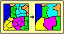
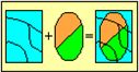
Dissolve aggregates features that have the same value for an attributes. |
|
|
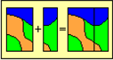
Merge appends the features of two layers into a single layer. |
|
|
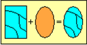
Clip uses a clip layer on your input layer. The attributes are not altered. |
|
|
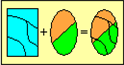
Intersect cuts an input layer with the features from an overlay layer to produce an output layer with features that have attribute data from both. |
|
|
Union combines features of an input layer with polygons of an overlay layer to produce an output layer that contains the attributes and full extent of both layers. |
In this chapter, the manipulation of each operation will be introduced. To open "Geoprocessing Tool" window, please click "Geoprocessing Tool" in "Tools" menu.
.png)
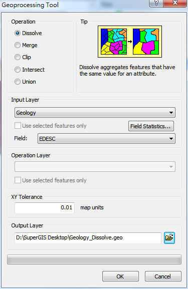
"Geoprocessing Tool" window can be divided into 6 blocks:
A. |
Operation: 5 different computations and the definitions are listed. |
B. |
Input Layer: the layer you would like to process with. You can choose whether to tick Use Selected Features and specify the field. Then, you can proceed with field statistics and also display the results in the attribute table of the output layer. |
C. |
Operation Layer: the target layer. Users can choose whether to tick Use Selected Features to aggregate the selected features only. |
D. |
Output Layer: you can set the path for saving and the name of the output layer file. The default path for saving is the folder of the input layer. The default file name is “the name of input layer_operation”, such as geology_Dissolve. |
E. |
XY Tolerance: Take the current map unit as standard, default value of the XY Tolerance is 0.01. |
F. |
Progress Bar: the geopressing progress is displayed here. When you process quantities of data, please be patient to wait for the results. |
©2015 Supergeo Technologies Inc. All rights reserved.