
Create New Cache
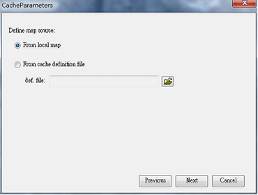
1.Before creating a map cache, you have to define the map source. It can be from local map, or from cache definition file (add anchor link). Afterwards, click Next to go to Cache Settings page.
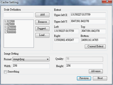
2.Here, you have to define the scale definition, extent, and image settings for the cached map.
a.In Scale Definition, enter the required scales for the cached map, you can add manually, use suggested scales by clicking Suggest…, or load predefined scales (add anchor link).
b.In Extent, define the map cache origin and extent. By default, the origin will be shown at the upper-left corner of the map cache extent; and the extent will be the map layers’ boundary. You can also click Current Extent to set the map extent as the current display extent on SuperGIS Desktop.
c.In Image Setting, set up the file format of cached map, image quality, width, height and smoothing. If your cache map does not need transparency settings, you can set the output image as a JEPG file to reduce the file size. You can also use the mix mode to assign different formats to layers (add link). Click OK as all settings are finished.
※Note: You can predefine cache scale schemes with a *.xml file. To do so, use text editor to define a scale scheme. Now, follow the sample below to create your own scale schemes.
Sample: Create a scale scheme containing 5 scales, 1/50000, 1/25000, 1/10000, 1/5000, and 1/2500.
<ScaleDef>
<Scale>2500</Scale>
<Scale>5000</Scale>
<Scale>10000</Scale>
<Scale>25000</Scale>
<Scale>50000</Scale>
</ScaleDef>
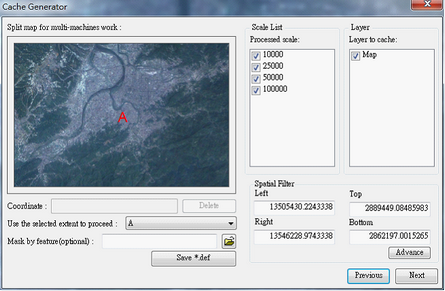
3.Subsequently, go to the second Cache Settings page where you can define spatial filter, processed scales and layers, and use feature mask.
a.You can split map through multi-machine works to reduce process duration. After splitting the map, please remember to save the result as a *.def (cache definition) file; so that you can apply the same settings to create the cache next time.
b.Select the proceeded extent as the spatial filter; there will be one extent set by default. You can also use feature layers as spatial filter or simply custom your spatial filter .
c.Select/tick the scales and layers to proceed. Only the ticked scales and layers will be cached.
d.If you want to generate caches within a given geometry area, please import polygon features by clicking “mask by feature” and mask the caches.
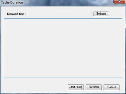
4.After all settings are completed, users can generate cache in the Caching Map window, and choose the path to export cache. You can click Estimate to estimate the work duration- Click Start/Stop to start caching process and click again to stop it. The dialog will show information about the caching process. As the cached map is completed, a message asking if you want to add the layer to the current map shows up. Click OK to add the STP; otherwise, click NO.
©2015 Supergeo Technologies Inc. All rights reserved.