
Parameters of Generate Network Data
In the workflow of Network analysis, firstly, we need to sketch the relative position of the roads on a layer in *.geo or *.shp file. Then, convert the feature class network to NRT format using the convertor program to create the connectivity, topology and attribute data, including turn type, one-way road, length, speed limit of the segments(obtained from the real feature class network ).
In conversion, you need to assign the fields to convert (stored in the corresponding .dbf file of the line network file to convert). Now we are to introduce the parameters in conversion settings.
1. Name field
Choose a field from the drop-down menu. This field must contain the information of all segments, mostly are road names. You can access the name of each segment through this field when inquiring roads using Inquiry Road tool. If this field is not assigned in conversion, the road name in the result will be blank.
2. Way field
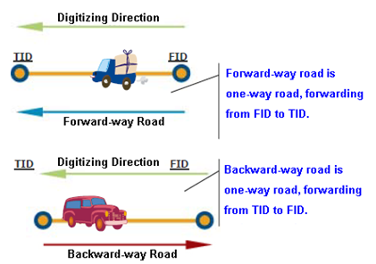
It has four way types, two-way road, forward-way road, backward-way road, and no way. The forward-way road and backward-way road belong to one-way road; identifying a road is forward-way or backward-way road depends on the digitizing direction of road. Please refer to the figure below.
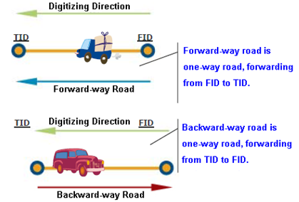
From the figure above, we learn that a one-way road will be defined as a forward road or backward road based on the digitizing direction. Two-way roads allow users to drive in both directions. No way doesn't allow users to travel.
3. Weight field
Weight field represents the cost of each segment. A segment with lower weight stands for less time cost or distance cost, so that it has more chance to be chosen to travel on. See the figure below, route A is shorter than route B, but route B has less weight value, at last, route B is chosen as the route result.
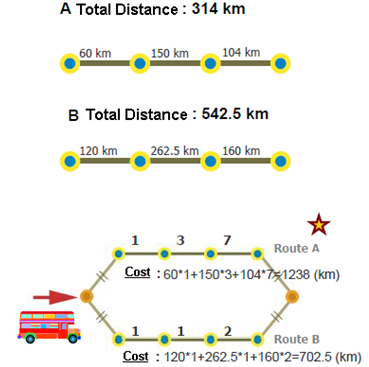
See the example above, route A has three different segment weights, 1, 3 and 7; route B also has three different segment weights, 1, 1 and 2. Even though a bus driver is eager to transport the tourists to the destination by driving on the shortest path (so that he can go home earlier), in this case, route A has heavy traffic, which takes much more time than route B. We can evaluate the two routes based on their respective segment weight values. For instance, driving on a road whose weight is “2” means the driver has to spend twice the cost to drive on it, that is, an 160 km-trip will double to 320 km.
After that, we evaluate the two routes and find their individual weight cost is 1238 (route A) and 702.5 (route B). Any one of the bus drivers will pick and drive on route B, even though the distance is much longer.
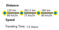
4. Speed field
Speed, the average speed when one drives on the road segment. When calculating the cost of each segment (the driving time), speed and segment length will be put into consideration.
5. Hierarchy field
The road hierarchy can be classified into three major levels:
0: Primary: The road of the highest level, in general, it refers to Freeway or Expressway.
1: Secondary: The road of medium level, it refers to the major roads or the arterial roads.
2: Local: The road of the lowest level, equals to the local streets.
If you perform the route planning with hierarchy, the calculation will aim to find out and pick the road of higher level.(Please refer to Hierarchy for the details)
6. Turn and Cost Field
Users can determine whether to set the turn settings or not by setting Simple or Complete. The setting allows users to get the turn type of two segments by defining the angle and thresholds. See the figure below, treat the forward direction of source segment as 0°, if the angle with the target segment is between 0°~30° or 330°~360°, the turn type with the target segment is defined as U-turn; between 30°~150°, the turn type with the target segment is defined as left-turn; between 150°~210°, the turn type with the target segment is defined as go-straight; between 210°~330°, the turn type with the target segment is defined as right-turn.
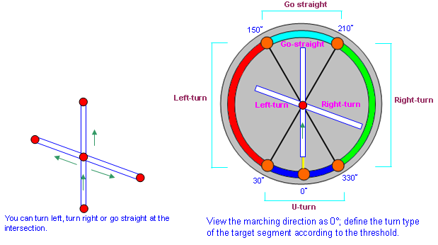
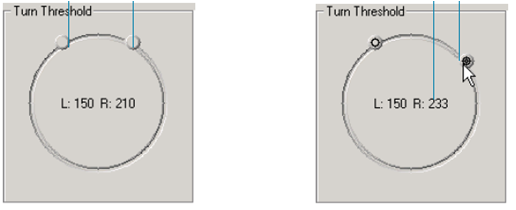
In addition, you can assign different turn cost (unit: second) for different turn type in conversion. Turn cost is basically an intuitive problem; a right-turn might takes you 5 seconds more (even with the turn-right traffic light), but a left-turn might take much more cost. The cost differs in different area due to the different traffic circumstances. The default turn cost for go-straight is 5, right-turn is 20 and left-turn is 10. You can set the turn threshold as below:
Click the threshold indicator and adjust it by moving around the circle. Setting the right threshold indicator determines the lower bound of right-turn; setting the left threshold indicator determines the upper bound of left-turn. Click and drag the threshold indicator and you will see the value changes as mouse moves; besides, the threshold value of the right and left will be rationally modified.
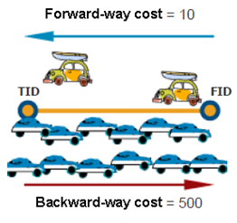
7. Cost of Forward-way and Backward-way
In the real situation, we need to consider displaying a two-way road by multi-polyline to represent the forward-way and backward-way state, that is, to use two polylines to represent the two different directions. But, in this way, the data of two-way road will double, which decreases the analysis performance. Therefore, the attributes of a single polyline to identify the cost difference is offered in SuperGIS.
Take a real world example, supposing a two-way road(see the figure below), it is server traffic jammed in rush hours in the backward-way direction, we can set the backward-way cost a comparatively higher value, like 500, to reduce the chance to pick this segment in analysis. However, because the forward-way cost of the same segment is comparatively much lower, the chance to pick it to find the optimal route in analysis is increased. Due to the reason mentioned above, this segment will be considered as two different segments when performing analysis.
NOTE 1: The field type of ID Field should be INTEGER.
NOTE 2: In Way Field, field type is INTEGER, which can be 0, 1 and 2. These numeric value define different road types :
0 defines Two-Way
1 defines Forward-Way
2 defines Backward-Way
8. Road Type
It provides four road types, two-way road, forward-way road, backward-way road and no way. The forward-way road and backward-way road belong to one-way road; they are determined by the digitizing direction. Please see the figure below for a quick understanding.
©2016 Supergeo Technologies Inc. All rights reserved.