
Hierarchy
The latest version of Network Analyst extension of SuperGIS Desktop integrates the concept of road hierarchy to network analysis, which greatly enhances the searching efficiency. Besides, users are able to plan the most suitable and required route through setting the hierarchy of road. In this chapter we will state clearly the concept and manipulation of hierarchy.
The hierarchy in Network considers the traditional network data as the 3 dimensional data instead of 2 dimensional data. In network data, the roads can be divided into different levels based on their characteristics, as a result, through the levels of network data, we can find a more reasonable and accurate result by considering the restriction on road hierarchy. For instance, during the busy hours of freeway, such as peak hours or holidays in a row, people would prefer to drive on local roads instead of the freeway since they might possibly encounter server traffic jams. In that case, we can perform the network analysis using hierarchy and find a more reasonable route which fits the real situation better.
The latest version of Network Analyst extension in SuperGIS Desktop now supports Network Hierarchy. You are able to set the “HRC settings” to divide the network data into different levels when converting network data. HRC is the abbreviation of Hierarchy which allows users to increase the hierarchy information to network data when converting network data before network analysis. In the process of network analysis, you need to consider all factors which might influence the analysis result, such as road weight, speed limit or road hierarchy, so preparing the complete road data is a must, besides, the network data using hierarchy will contribute even accurate result and better analysis performance.
The concept of hierarchy is suitable for all kinds of network analysis. To Network Analyst extension in SuperGIS Desktop, hierarchy can be applied to most analysts, including Shortest Path, Superior Route, Vehicle Routing Problem, Closest Facilities, Location Analyst and Location Allocation. Now only Service Area doesn't support it.
The hierarchy of road can be classified into three major types:
0: Primary: The road of the highest level, in general, it refers to Freeway or Expressway.
1: Secondary: The road of medium level, it refers to the major roads or the arterial roads.
2: Local: The road of the lowest level, equals to the local streets.
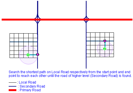
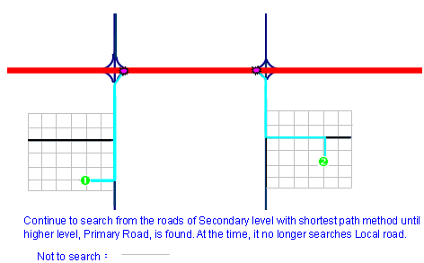
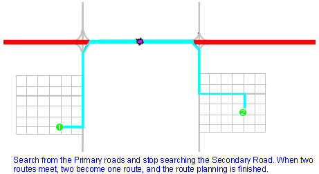
When performing route planning with hierarchy, the computing will search the road of higher level gradually. The route planning is like that the two end points (start and end point) will go forward to find the other, and the searching starts from the roads where the two points are located. It is assumed that a start point is located on the road of local level; once the route planning has searched the road of secondary level, it will choose to drive on the road of secondary level. Then all the roads of local level will be filtered out, and the route planning no longer searches among them. After that, when the road of higher level, primary road, is searched, the route planning will adopt the road of primary level. Meanwhile, the roads of lower levels, secondary and local roads, will be filtered out. At last, when the start and end point find the route to reach each other with the method mentioned above, two routes become one route through connection, the route planning is finished.
To the far destinations, the drivers usually consider to use Expressway or Freeway as priority when performing the route. So they can save a lot of time on the local streets, turns and the red lights. Although the total distance they drive might be even longer, they will reach the destination much faster. In the respect of computing speed, performing Network Analysis with Hierarchy will be faster than without it.
However there are some disadvantages in using Hierarchy. Hierarchy favors the roads of higher level as priority so it is possible for the route planning not to choose the general roads which are closer but choose the farther Freeway. This will take higher cost. So we suggest, after the route result using hierarchy is obtained, perform the route planning again without hierarchy, and then find the suitable route from the two.
©2016 Supergeo Technologies Inc. All rights reserved.