
SuperGIS DataManager and Geodatabase
SuperGIS DataManager supports several types of Geodatabases and enables users to upload geospatial data to Personal Geodatabase,SQLite DB, MS SQL Server, Oracle Spatial, and PostgreSQL.
With SuperGIS DataManager, users can view and manage the MDB files (Personal Geodatabase) in the host computer and also can export and upload Feature Class to the Geodatabase. Moreover, SuperGIS DataManager is capable of connecting to MS SQL Server, Oracle Spatial, and PostgreSQL on a remote computer; users are allowed to view and manage the data in remote database through SuperGIS DataManager.
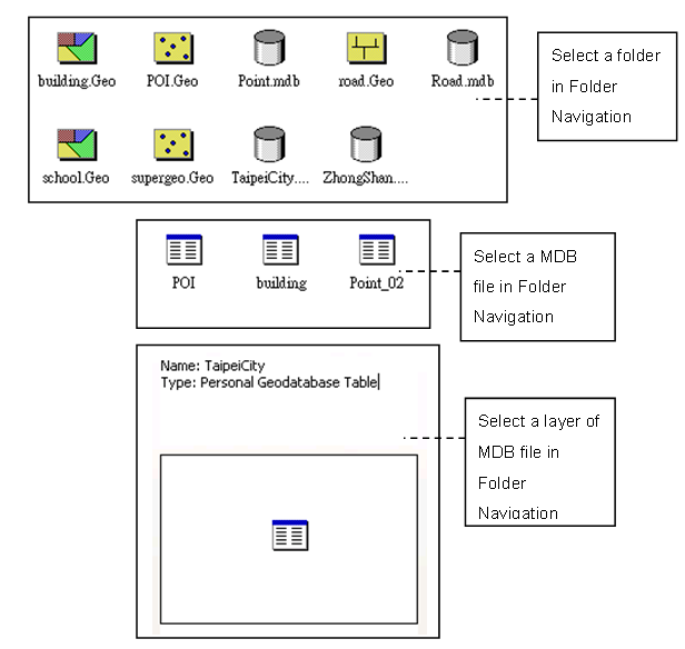
SuperGIS DataManager supports to view MDB files in Personal Geodatabase. In the left part of SuperGIS DataManager, users can manage (delete, copy, paste, and rename) the data and view the location of the data. The right part of the window displays the contents of the folder you selected in Folder Browser. For example, if you select a folder in Folder Browser, the files in the selected folder will be listed in the right part of the window. If you select a MDB file in Folder Browser, all of the layers in the MDB file will be listed in the right part. If you select a layer in a MDB file, the name and the type of the layer will be displayed .
Users can create multiple connections to various Geodatabases in SuperGIS DataManager. When the connection is created, you can view the contents in Database Connection in Folder Browser in SuperGIS DataManager. The way to view the data in Geodatabase is similar to the vector data. You can switch the tabs in Data Display area in SuperGIS DataManager to view the contents of the data and the data in attribute table online.
SuperGIS DataManager, now, supports the Geodatabases, including Microsoft Access 2000 (Personal Geodatabase), SQLite DB,Microsoft SQL Server, Oracle Spatial 10g/11i, and PostgreSQL.
Moreover, SuperGIS DataManager can manage the data and upload the data to the Geodatabase, which can cooperate with SuperGIS Server to create Geodatabase maps and publish Geodatabase map services. Thus, the related GIS websites can be created and OGC services can be published. About the associated details, please refer to SuperGIS Server manual.
© 2015 Supergeo Technologies Inc. All Rights Reserved.