
SuperGIS Cube Standard Toolbar
Standard Toolbar includes some basic manipulation of SuperGIS Cube, including create and load SuperGIS Cube project files and so on. This chapter explains each of the tools in this toolbar.
![]() Open new file
Open new file
Click to open a new SuperGIS Cube project file. If the current project is not saved before you open a new project, you will be asked if you want to save the current project file. Click yes to save; click no to open a new project file without saving; click cancel to cancel opening a new file.
![]() Open existing files
Open existing files
Open an existing SuperGIS Cube project file. After you open a project file, all the layers and settings in the project will be loaded. The SuperGIS Cube project file is in *.3dg file format.
![]() Save file
Save file
Saves the current SuperGIS Cube project file. All the layers and settings will be saved and will be loaded when opened. The SuperGIS Cube project file is in *.3dg file format.
![]() Print
Print
Prints the current view of SuperGIS Cube.
![]() Add layers
Add layers
Add the layers supported SuperGIS Cube, including raster, vector, *kml, *.kmz, CityGML.
![]() Add Terrain
Add Terrain
Add the DEM files supported by SuperGIS Cube, including *.lan and *.sgr.
![]() Manual
Manual
Open the manual of SuperGIS Cube.
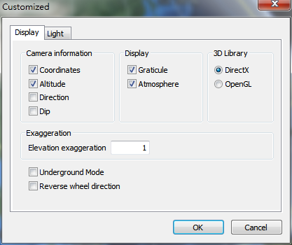
![]() Settings
Settings
Users can choose to show camera information, and set the elevation exaggeration.
1.Camera information: Users can choose to show camera coordinates, altitude, direction, dip, and whether to show graticule or not.
2.Exaggeration: Set the elevation exaggeration. The displayed elevation will the the original elevation multiplied by this value, which is between 0.01 to 3.00.
© 2016 Supergeo Technologies Inc. All Rights Reserved.