
Zone Geometry
Zonal Geometry, Zonal Geometry as Table
Zone Geometry quantifies the geometry types (area, perimeter, thickness and centroid) with the concept of zone and gets the output for each zone.
Zonal Geometry as Table outputs the analysis result as a table instead of a raster.
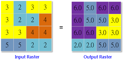
Area
Area refers to the total area of the zone. See the figures below, there are six cells with value of 3, so the cell locations with value of 3 in the input raster will have a output value as 6.0.
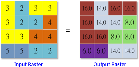
Perimeter
Perimeter calculates the perimeter of zone raster and outputs. The boundary shared by the two neighbor cells that have the same value will not be calculated. But the boundaries inside and outside the raster must be included in calculations. See the figure below (the cell size is 1), there are six cells that have the value of 3, the boundaries are 16 units. As a result, the cell locations whose value is 3 in the input raster, will have a output value of 16.0.
Thickness
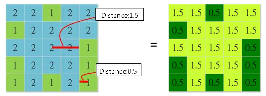
Thickness can be used to remove the noise area or the unrelated data. Once the analysis starts, Extraction analyst and other functions can also be used to remove the area smaller than a specific value or thickness.The analysis calculates the maximum radius in each area and gets the corresponding output cell values.
See the figure below:
1.The cell size of the raster is 1.
2.This raster is divided into two zones, 1 and 2.
3.Find the deepest cell in the two zone rasters (the zone cell does not connect the zone cell of the other zone raster).
4.The deepest cell of "Zone 2" is in the center; because each zone cell of "Zone 1" connect zone cell of another zone raster(the same thickness), so we pick one to represent.
5.The thickness is the shortest distance calculated from the zone boundary to the deepest zone cell.
Centroid
The centroid can be found in each zone. The output raster that is located in the centroid of the zone will be assigned with the zone value. For instance, two or more zone centroids are found in a raster, the lowest zone value will be taken to be the output value.
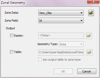
Description of Parameters
Item |
Description |
Data Type |
Zone Data |
The zone data that will be analyzed. |
Raster layer/Feature layer |
Zone Field |
The weight or value that will be calculated. |
Attribute field |
Output Raster |
The filename and path of the output raster. |
Raster layer |
Geometry Type |
The geometry type to be calculated: •Area: to calculate the area of each zone. •Perimeter: to calculate the perimeter of each zone. •Thickness: Calculate the widest distance in the area. •Centroid: calculate the centroid of each area. |
Analysis option |
Output Table |
The filename and path of the output table. |
DBF |
Join output table to zone layer |
Join the output attribute table to the zone layer (only for feature layer). |
Feature layer |
©2016 Supergeo Technologies Inc. All rights reserved.