
Zonal Statistics
Zonal Statistic and Zonal Statistic as Table
Zonal statistics calculates or performs the statistics with the values of the value raster. Then get the statistics values for each zone based on the zone raster. A zone is defined as all the cells that have the same value in the input (the discontinuous cells of same value are accepted to be a zone).
Zonal Statistic as Table shows the result in Table instead of raster.
Zone raster defines the shape, value and position of the zone, and the input value raster provides the original data for calculation. Ten statistics types are available, Majority, Minority, Maximum, Mean, Minimum, Median, Range, Standard deviation, Sum and Variety.
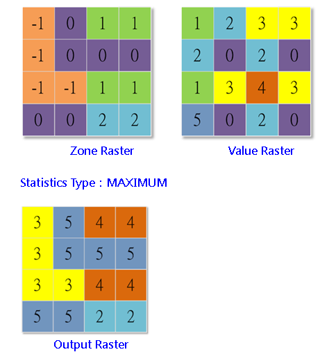
Zonal statistics analyzes the situation in zones. For instance, users can analyze the lowest elevation of each sink using the zone statistics analysis, and then employ Zone Fill to get the lowest elevation of outlet and get the depth of sink. This is quite helpful for filling the wrong sinks and reducing the elevation of basin boundary.
Description of Parameters
Item |
Description |
Data Type |
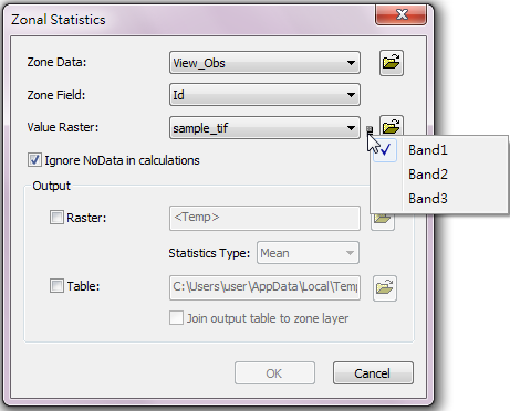
Zone Data |
The zone data to perform analysis. |
Raster data/Feature class |
Zone Field |
The weight or value that will be calculated. |
Attribute field |
Value Raster |
The value raster that will be calculated. Users can click the |
Raster data |
Ignore NoData in calculations |
Whether to ignore the cells that are NoData in neighborhood. |
Analysis option |
Output Raster |
The filename and storage path of the output raster. |
Raster data |
Statistics Type |
The statistics type: •Minimum: calculate and get the minimum •Maximum: calculate and get the maximum •Range: calculate and get the difference of the maximum and minimum •Sum: calculate and get the sum •Mean: calculate and get the mean •Standard Deviation: calculate and get the standard deviation •Variety: calculate and get variety •Majority:calculate and get the majority •Minority: calculate and get minority •Median: calculate and get the median |
Analysis option |
Output Table |
The filename and storage path of the output table. |
DBF |
Join output table to zone layer |
Join the output attribute table to the zone data (only for feature class). |
Feature layer |
©2016 Supergeo Technologies Inc. All rights reserved.