
What is spatial data and geoprocessing?
Spatial data is any of the information that relates to the feature's geographical location, shape and topology. In GIS environment, the narrow spatial data can be divided into vector and raster data. Vector data presents the spatial feature with geometry objects like point, line and polygon. Raster data fills the spatial extent with a set of identical squares in which a digital represents the spatial phenomenon, and the different spatial phenomenon can be presented with the change of such information. The board spatial data includes all the variant related to “Spatial”, in addition to longitude, latitude, coordinates, the terrain, landform, climate, phenomenon, economic development, behavior or even neighborhood of the observing object are also included in.
Integrated different data with 3S(GIS, GPS, RS) is a trend in GIS analysis application. As the related technologies have been developed constantly, how to quickly and effectively be familiar with the spatial data and understand, describe and predict in reality with related technologies has become the global GIS users' need and goal.
Spatial analysis is the crucial part of GIS. In GIS environment, with spatial analysis tools, the original spatial data can be transformed to solve some specific problems and further, get the messages in or behind data. Or classify the sample data into different regions and observe if the neighborhoods have influenced these regions. Or combine spatial data with time factor and explore the data on it time and spatial features. Finally, process based on the need, such as quantifying, query, analyzing and mapping.
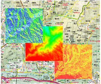
Display the spatial data of surface
Through the digital elevation, the terrain of surface can be displayed, such as slope analysis, aspect analysis.
Present the Spatial Connectivity
Use the range analysis to get the connectivity between landmarks and the dependency between roads.
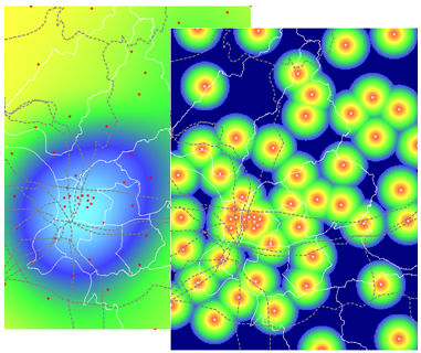
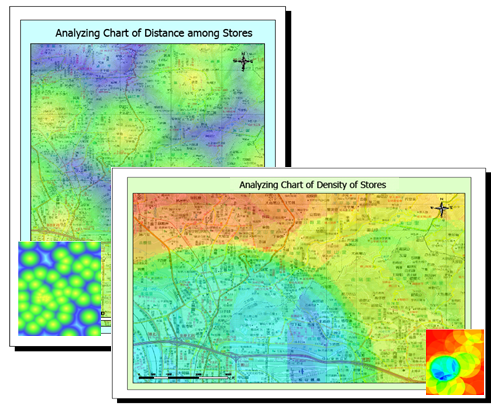
Find the suitable site location
Find the suitable spatial site location and the connectivity through distance and density analysis.
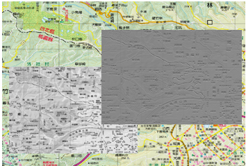
The enhancement and display of the image information
Filter the unnecessary noise with filter analysis to enhance the image information.
©2016 Supergeo Technologies Inc. All rights reserved.