
Watershed
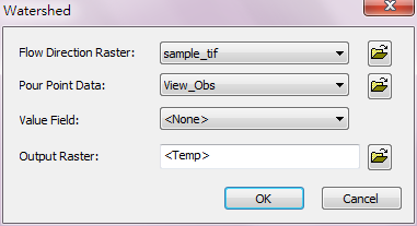
Watershed analysis takes not only flow direction information but also the location of the watershed or pond area to be the basis to separate the watershed. In the mean time, setting the threshold (flow volume) defines the minimum volume of the pour point of the watershed.
Description of Parameters
Item |
Description |
Data Type |
Flow Direction Raster |
The input flow direction raster. |
Raster data |
Pour Point Raster |
Input the pour point locations. |
Raster data/Feature layer |
Output Raster |
The filename and storage path of output raster. |
Raster data |
©2016 Supergeo Technologies Inc. All rights reserved.