
Snap Pour Point
The output raster of the Basin Analyst has great watershed extent, so, in hydrology analysis, sometimes we will need to split it to subsets. In this case, we need to learn the locations of the pour points of the subset before processing the analysis.
In some study, users might hope to split to subsets by defining the pour points. However, the pour points defined by users might not fall on the reasonable positions. With the Snap Pour Point Analyst, it helps to snap the pour points to locations with the greatest flow accumulation within the specified snap distance, so the locations will have the greatest flow accumulation.
Description of Parameters
Item |
Description |
Data Type |
Pour Point Raster |
The pour point locations for snapping. |
Raster data |
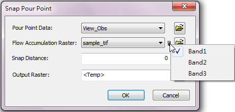
Flow Accumulation Raster |
The input flow accumulation raster. Users can click the |
Raster data |
Snap Distance |
Set the largest searching radius. |
Integer/Floating point |
Output Raster |
The filename and storage path of output raster. |
Raster data |
©2016 Supergeo Technologies Inc. All rights reserved.