
Reclassify
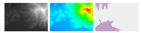
"Reclassify" means that when the input raster values can not satisfy analyzing command, users are able to replace those old values with new ones and output a new raster. It enables users to utilize substitute values, specified interval values or region reclassification to alter one or a group of raster values each time. For instance, to complete reclassifying through integrated classifications, users can classify different sorts of values into a unique sort to simplify or combine some categories, or reclassify various rasters by intervals based on sensitivity, priority, etc.
Description of Parameters
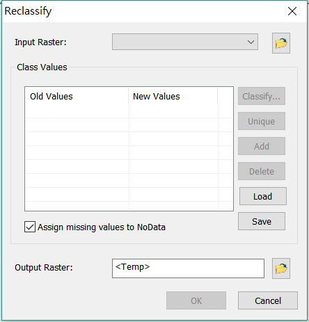
In Spatial Analyst 10, you can load a table as reclassification rule. Also, you can save your reclassify configuration for reusing.
Description of Parameters
Item |
Description |
Data Type |
Input Raster |
The data raster to be reclassified. |
Raster layer |
Classify |
Reclassify the original value of the raster based on the specified method and condition. |
Analysis option |
Unique |
Classify the cells of same value into same class. |
Analysis option |
Add |
Add class. |
Analysis option |
Delete |
Delete class. |
Analysis option |
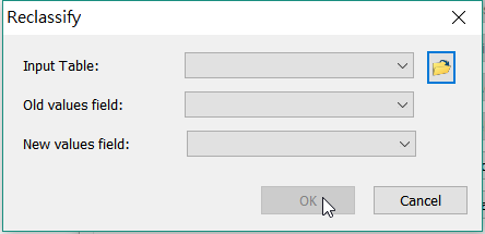
Load |
Load table data from external source to define the old value and new value. Class information could be numerical ranges (e.g., 3-7, 9-12) or a number. |
Analysis option |
Save |
Save current reclassify settings as a table format supported by SuperGIS Desktop. |
Analysis option |
Assign missing value to NoData |
Treat the cell values that are not contained in the reclassified list as NoData. |
Analysis option |
Output Raster |
The filename and path of the output raster. |
Raster layer |
©2016 Supergeo Technologies Inc. All rights reserved.