
Generate Stream Raster
The flow accumulation represents the water volume of a cell , so assumed the surface flow will be generated when the cell value reaches a specific number. In this case, those cells with values larger than the threshold should be the potential flow path, as a result, the network made by the flow paths produces the stream raster.
Stream raster differs from the general rasters, we can generate it with Spatial Analyst on SuperGIS Desktop. To generate the stream raster and flow direction raster which is required for Stream Link, you need a raster with terrain and then follow the steps below to complete it.
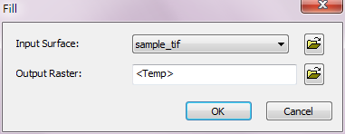
1.Run Hydrology > Fill and remove the unnecessary sink data from the terrain to improve the correctness of the hydrology data.
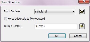
2.Take the Fill output raster and run Hydrology > Flow Direction to get the flow direction raster. "Force edge cells to flow outward" is optional.
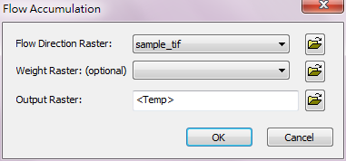
3.Take the Flow Direction raster obtained by step 2 and run Hydrology > Flow Accumulation to get the flow accumulation data. "Weight Raster" is optional.
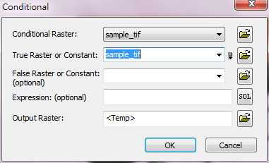
4.At last, take the flow accumulation raster obtained by step 3 and run Hydrology > Conditional to set the threshold of the flow accumulation to get the stream raster. For instance, to set the threshold of flow accumulation as 600, we need to input [Value]>600 in Expression field and set the "True Raster or Constant" 1 so that a stream raster with a flow accumulation threshold of 600 will be produced. The so-called flow accumulation threshold will differ based on the geology, soil, terrain, climate factors of the analyzing region, which will not be discussed here.
The Stream Raster and Flow Direction Raster produced above can respectively used as the input raster for Stream Link. As a result, you can run Stream Link and output the structure layer for stream network analysis.
©2016 Supergeo Technologies Inc. All rights reserved.