
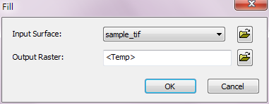
Fill
Sinks are often errors caused by the insufficient resolution of the data, real surface condition or measurement inaccuracy, which result in the unreasonable flow direction. To model the flow direction meeting the eight-direction code and more continuous, we can fill the sink with elevation data by using the Fill Analyst.
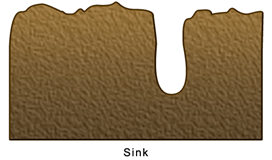
Fill analyst iteratively fills the sinks based on elevation and flow direction. For instance, a sink that just has been filled could be a new sink when compared with its neighbor areas. Through continuous filling until all the sinks are filled, the analysis is finished. However, some of the sinks might reflect the real situation; in that case, we can set the fill threshold to do more reasonable judgment.
Description of Parameters
Item |
Description |
Data Type |
Input Surface |
The elevation surface to perform Fill analysis. |
Raster data |
Output Raster |
The filename and storage path of output raster. |
Raster data |
©2016 Supergeo Technologies Inc. All rights reserved.