
Cut/Fill
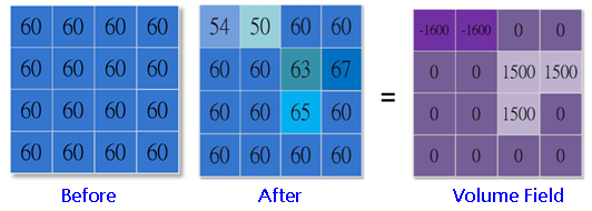
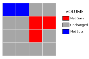
Cut/Fill analysis analyzes the change on the surface area and volume of an identical region in different periods of time. Cut/To two maps at the same location in different periods of time, the Fill tool effectively exhibits the addition, removal or no change.
Cut/Fill tool not only displays the change of surface but also quantifies the change. The output value of Cut/Fill could be positive, negative or 0. If the output value is negative, it represents the deposition is running at the site; if it is positive, it represents the erosion and removal occur at the location.
Cut/Fill analysis helps analyze the deposition or erosion condition in a valley. Or it helps calculate the area or volume of the surface material to be removed or filled at the construction site. Or it helps find a stable region suitable for habitat where the water periodically overflows.
Description of Parameters
Item |
Description |
Data Type |
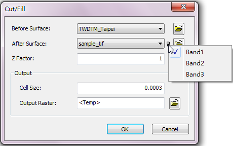
Before Surface |
The early stage raster data to be performed surface analysis. |
Raster layer |
After Surface |
The later stage raster data to be performed surface analysis. Users can click the |
Raster layer |
Z Factor |
The default is 1; it means the unit of vertical and horizontal direction are the same. |
Integer/floating point |
Cell Size |
The cell size of the output raster. |
Integer/floating point |
Profile Curve Raster |
The output profile curve raster, to present the sharpness of slope. |
Raster layer |
Plan Curve Raster |
The output plan curve raster, to present the curviness of the contour. |
Raster layer |
Output Raster |
The filename and storage path of the output raster. |
Raster layer |
©2016 Supergeo Technologies Inc. All rights reserved.