
Set Survey Toolbar
Tap ![]() , the survey toolbar setting page appears. Five items:
, the survey toolbar setting page appears. Five items:
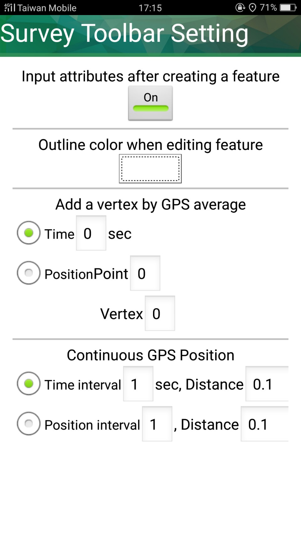
•Input attributes after creating a feature: If set it On, the attribute table window shows up right after a feature is created. If set it Off, no attribute table window shows up after a feature is created; in that case, to edit attribute you need to select the feature first and use "Edit Attribute" so the attribute table windows will appear.
•Outline color when editing feature: Set the outline color when editing feature.
•Snap to vertex when editing feature: When editing features, the new or editing feature is able to snap to other existing feature within the specified tolerance. Users can switch on/off the function, the unit is pixel.
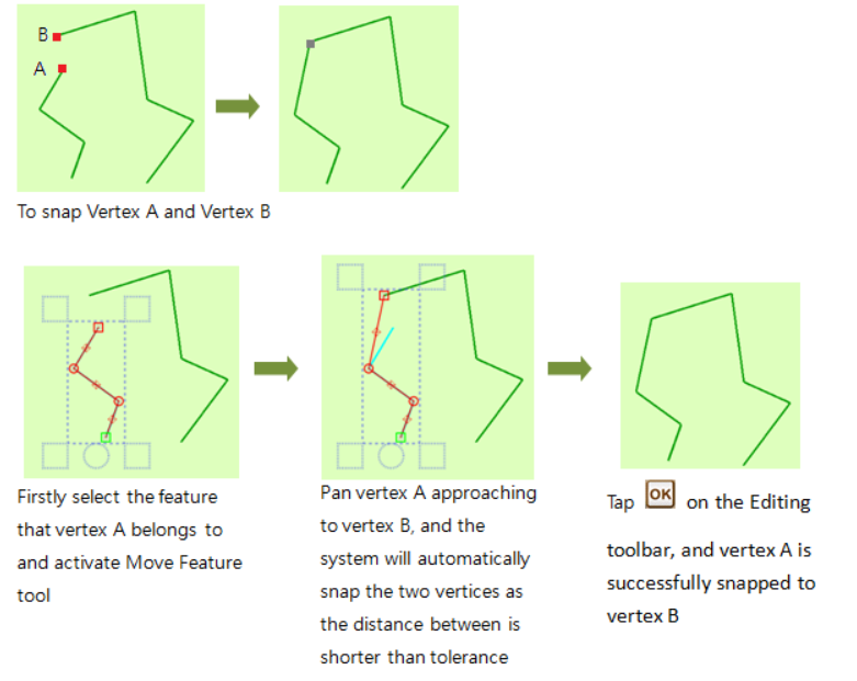
Please note that, to activate snapping when editing features, firstly, you need to set "Snap to vertex when editing features" on and specify the tolerance. Sequentially,
SuperSurv allows snapping vertices with tolerance automatically. To snap two vertices, please select the feature to snap and then activate Move Vertex function so that you can pan vertex A which you want it to be snapped to vertex B by approaching to vertex B. As the distance between the two vertices is shorter than tolerance (you set in Snap to vertex when editing features, the unit is pixel), vertex A will be snapped to vertex B automatically. Please refer to the illustration below.
•Add a vertex by GPS average: The function used to collect and add point(s) or vertices of point, line and polygon layer.
(1) Time: Please fill in the blank with a number which will stand for the time interval (second) for GPS to add a vertex. Fill in with 1; the GPS adds a vertex every second. Fill in with 2; SuperSurv will average the positions of the collected vertices every 2 seconds and adds the point/vertex on the map.
(2) Position: The Point setting is for collecting point data while the Vertex setting is applicable for collecting the vertices of line/polygon data. Please fill in the blank you require with a number. Fill in with 1; the GPS adds every point it collected. Fill in with 2; SuperSurv now averages positions of every 2 vertices it collected and adds the vertex on the map.
•Continuous GPS Position: The function used to collect data (or vertices) of point, line and polygon layer.
(1) Time interval: Please fill in the Time interval with an integer which stands for the time interval (second) for GPS to add a vertex. If you fill in with 1, SuperSurv will add its position every second. Subsequently, fill in the blank of Distance with a number which represents the distance (meter) threshold for the data collection. Fill in with 1; SuperSurv will add every next point while the distance among them is at least 1 meter.
Notice: condition 1 and 2 must be matched at the same time.
(2)Position interval: Please fill in the blank of Position interval with an integer which stands for the specified points collected by GPS. Fill in with 1; SuperSurv will add every collected point on the map. Fill in with 2; SuperSurv will add the even points it collected. Subsequently, fill in the blank of Distance with a number which represents the distance (meter) threshold for the data collection.
© 2017 Supergeo Technologies Inc. All Rights Reserved.