
How to create waypoint file?
You can create waypoint files on PC and then copy the files to the mobile device. Then, you can import the waypoints to SuperSurv. SuperSurv supports to import waypoints in TXT, CSV, or KML file. If you use TXT and CSV format, please follow the rules below:
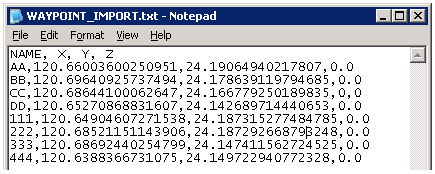
•Column names: the order is Name, X, Y, and Z. They stand for waypoint name, X coordinate, Y coordinate, and elevation.
•Punctuation: use comma to split each column.
•Coordinate system: XY coordinates can be projected system or WGS84 format. If you use WGS84, please use degree.
•Z value: Z value is the elevation of waypoint. The unit is meter. Z value is an optional column; you can choose whether to enter the value.
© 2017 Supergeo Technologies Inc. All Rights Reserved.