
Turn On/Off GPS
1.Tap the GPS button on the main toolbar, switch to GPS toolbar, tap Turn On GPS ![]() to connect SuperPad and GPS receiver. After GPS is activated, the icon turns green
to connect SuperPad and GPS receiver. After GPS is activated, the icon turns green![]() .
.
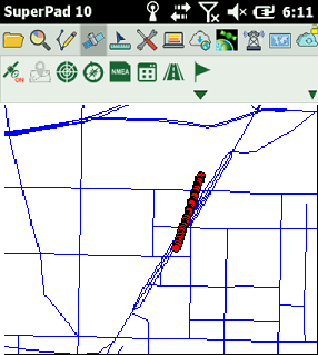
2.After GPS positions successfully, a GPS status bar appears on the bottom of the map, indicating the information of longitude, latitude, date, time, speed per hour and altitude. If the coordinate information is displayed in degree format, it can be switched to numeric format as tapped with stylus or mouse on coordinate information, and if it is displayed in numeric format, you can tap it to switch to the degree format. If the unit of speed per hour is kilometer, it can be switched to mile as tapped with stylus or mouse on speed information.
![]()
![]()
A yellow cursor inside a red hallow circle ![]() represents the GPS position. And the yellow cursor
represents the GPS position. And the yellow cursor ![]() is pointing the heading direction, while the yellow trail by the end of the yellow cursor is GPS trail. The lighter the trail color is, the more distant the current GPS position is.
is pointing the heading direction, while the yellow trail by the end of the yellow cursor is GPS trail. The lighter the trail color is, the more distant the current GPS position is.
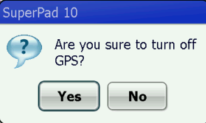
3.If you want to turn off GPS, tap Turn Off GPS and message box shows up. If you are sure to turn off, tap Yes; if not, tap No.
© 2017 Supergeo Technologies Inc. All Rights Reserved.