
Tracklog
In this tab the tracklog contents can be set up according to your request.
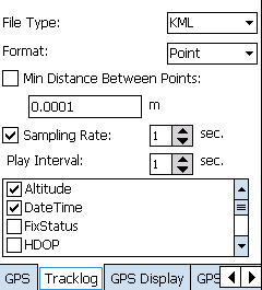
The contents include:
File Type: the tracklog can be saved in KML, SHP or GEO file. To KML, it can be read and displayed by various GIS software. Or to SHP and GEO layer, they can be used in Supergeo series products.
Format: Tracklog can be recorded in point, line or polygon. The point format tracklog displays in point. The line format tracklog displays in line. The polygon format tracklog displays in polygon. In other words, if the tracklog is saved to layer (*.geo or *.shp), the layer type will be identical to the recording format. As a result, point format transfers to point layer, line format transfers to line layer, and polygon format transfers to polygon layer.
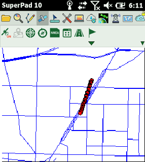
See the figure below. It is the tracklog saved in GEO layers in point format then being added to SuperPad.
Min Distance between Points: set the distance between the previous and next points when sampling. Unit is degree.
Sampling Rate: the sampling rate, the unit is second. It indicates how many seconds a sample will be taken.
Play Interval: set the unit is second. That is how many seconds a tracklog will be played.
© 2017 Supergeo Technologies Inc. All Rights Reserved.