
Three-Tier Toolbar
The three-tier toolbar is newly developed in SuperPad 10, which can be described in three tiers.
Main Toolbar: the top tier is the largest class, including six main classes: map/layer toolbar, browser toolbar, edit toolbar, GPS toolbar, system settings toolbar and Internet Application toolbar.
Corresponding Toolbar: in the second row toolbar on the map, the toolbar is corresponding to each main toolbar button.
Tool Menu: the tool menu appears on the third row when users tap the downward arrow of the tool on the toolbar group on the second row.
NOTE: Some of the toolbar buttons only have one single tool without the dropdown arrow. This kind of tools does not have tool menu.
To help users understand the functions of the tools, we will briefly introduce the functions of all tools below.
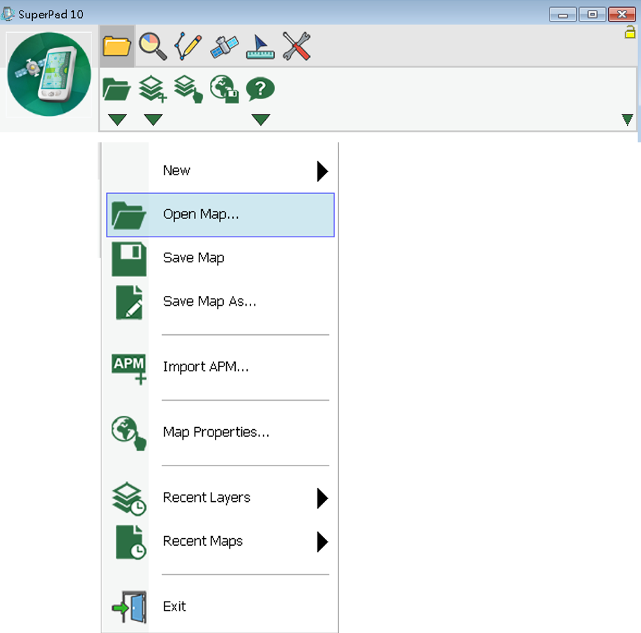
Map/Layer main toolbar ![]()
Icon |
Name |
Description |
|
Map/Layer main toolbar |
Open, save, add map/layer and layer manager. |
|
Explorer main toolbar |
Manipulate map, browse, zoom in/out, pan, identify, bookmark manager and hyperlink. |
|
Edit main toolbar |
Select a point/line/polygon feature, edit feature/vertex and add new features. |
|
GPS main toolbar |
Turn on/off GPS, record tracklog and GPS navigation settings. |
|
System Settings main toolbar |
Set up the various system parameters. |
Map/Layer toolbar ![]()
Icon |
Name |
Description |
|
Open Map |
Open a map file. |
|
Add Layers |
Add one or more layers. |
|
Layer Manager |
Manage the layers. |
|
Save Screen |
Save the screen. |
|
About SuperPad |
The version and copyright of SuperPad. |
Open Map tool menu
Icon |
Name |
Description |
|
New |
Create a new map, quick project, feature layer, photo layer and graphics layer. |
|
Open Map |
Open a map from files. |
|
Save Map |
Save the map. |
|
Save As |
Save map as a new file. |
|
Import APM |
Import ArcPad APM file. |
|
Print Setup (PC version) |
Set print settings. |
|
Print (PC version) |
Print. |
|
Map Properties |
The name, description and spatial reference of the map. |
|
Recent Layers |
The layers that recently opened. |
|
Recent Maps |
The maps that recently opened. |
|
Exit |
Close SuperPad. |
Add Layer tool menu
Icon |
Name |
Description |
|
Add Layers |
Add one or several layers. |
|
Layer Files |
Import or export the layer files (*.slr). |
About SuperPad tool menu
Icon |
Name |
Description |
|
About SuperPad |
Show SuperPad program version and copyright. |
|
User Guide (PC version) |
Online manual in PDF. |
|
Quick Reference (PC version) |
Quick reference of GPS tables and all tools. |
Explorer toolbar ![]()
Icon |
Name |
Description |
|
Zoom In |
Zoom in the map. |
|
Identify |
Query the attribute data. |
|
Zoom to Full Extent |
Go back to the previous map extent |
|
Go Back to Previous Extent |
Zoom to cover full extent. |
|
Find |
Search features by filtering condition. |
|
Refresh |
Redraw the map. |
Zoom In tool menu
Icon |
Name |
Description |
|
Zoom In |
Zoom in the area. |
|
Zoom Out |
Zoom out the area. |
|
Pan |
pan the area. |
|
Slide Zoom |
Slide upward and downward by touching the map to zoom out and zoom in map. |
|
Rotate Map |
Adjust the map rotation angle. |
|
Clear Rotation |
Clear the degree of the rotation. |
Identify tool menu
Icon |
Name |
Description |
|
Identify |
Tap map to query attributes. |
|
Hyperlink |
Tap features to open the linked webs or exterior files. |
Zoom to Full Extent tool menu
Icon |
Name |
Description |
|
Zoom to Full Extent |
Zoom map to cover all layers. |
|
Zoom to Layer |
Zoom map to the range of selected layer. |
|
Go to Bookmark |
Move map extent to bookmark extent. |
Go Back to Previous Extent tool menu
Icon |
Name |
Description |
|
Go Back to Previous Extent |
Open the previous map screen. |
|
Go to Next Extent |
Open the next map screen. |
Find tool menu
Icon |
Name |
Description |
|
Find |
Search features by filtering conditions. |
|
Create Bookmark |
Create new bookmark. |
|
Bookmark Manager |
To edit or delete bookmarks. |
Edit toolbar
Icon |
Name |
Description |
|
Select Feature |
Select a feature to edit. |
|
Vertex Edit |
Edit the feature's vertices. |
|
Point |
Create a point feature. |
|
Capture Point Using GPS |
Add a point feature at GPS position. |
|
Add GPS Vertex |
Add a new vertex using GPS. |
|
Add GPS Vertices Continuously |
Add vertices continuously using GPS. |
|
Feature Properties |
Edit attribute data. |
|
Text Point |
Add a text point. |
Select Feature tool menu
Icon |
Name |
Description |
|
Select Feature |
Select a feature to edit. |
|
Select at GPS Position |
Select a feature at GPS position. |
|
Clear Edit Selection |
Clear the edit selection. |
|
Zoom to Selected Feature |
Zoom the selected feature to the map center. |
|
Move to Selected Feature |
Move the selected feature to the map center. |
|
Repeated Attribute |
Repeat the attributes of the last created feature. |
Vertex Edit tool menu
Icon |
Name |
Description |
|
Vertex Edit |
Edit the feature's vertices. |
|
Move Vertex |
Move the vertex. |
|
Insert Vertex |
Insert a new vertex into the feature. |
|
Segment Polyline |
Continue to digital new vertices behind the last vertex. |
Point (add point/line/polygon feature) tool menu
Icon |
Name |
Description |
|
Point |
Create a point feature (for point layer). |
|
Line |
Create a line, a line feature (for line layer). |
|
Polyline |
Create a polyline, a polyline feature (for line layer). |
|
Freehand Line |
Create a freehand line, a line feature (for line layer). |
|
Polygon |
Create a polygon, a polygon feature (for polygon layer). |
|
Rectangle |
Draw a rectangle to create a polygon feature (for polygon layer). |
|
Circle |
Draw a circle to create a polygon feature (for polygon layer). |
|
Ellipse |
Draw an ellipse to create a polygon feature (for polygon layer). |
|
Freehand Polygon |
Draw a freehand polygon to create a polygon feature (for polygon layer). |
Edit Attribute tool menu
Icon |
Name |
Description |
|
Feature Properties |
Edit or modify attribute data. |
|
Move Feature |
Move the feature. |
|
Rotate Feature |
Rotate the feature. |
|
Offset Feature |
Offset the feature. |
|
Scale Feature |
Scale feature with the feature center as the standard. |
|
Resize Feature |
Resize the width or height of feature. |
|
Delete Feature |
Delete the feature. |
Edit Text Point tool menu
Icon |
Name |
Description |
|
Text Point |
Add a text point for a graphics layer. |
|
Text Polyline |
Add a text polyline for a graphics layer. |
|
Text Polygon |
Add a text polygon for a graphics layer. |
|
Text Rectangle |
Add a text rectangle for a graphics layer. |
|
Text Ellipse |
Add a text ellipse for a graphics layer. |
GPS toolbar ![]()
Icon |
Name |
Description |
|
Turn On/Off GPS |
Turn on or off GPS function. |
|
Tracklog Record |
Record GPS tracklog. |
|
GPS Status |
Current GPS status. |
|
GPS Position Information |
GPS navigation information. |
|
GPS Debug |
GPS signal record. |
|
GPS Options |
GPS settings. |
|
Pan To GPS |
Pan the map to GPS position. |
|
GPS Navigation Mode |
Activate the GPS navigation mode and head to waypoint. |
System Settings toolbar ![]()
Icon |
Name |
Description |
|
System Settings |
Set up the system parameters. |
|
Quick Explorer |
Whether to display the quick explorer or not. |
|
Add Waypoint |
Add a waypoint. |
|
Polyline Measure |
Measure distance, area and coordinates. |
|
Camera |
Take pictures with PDA through SuperPad. |
|
Run Script |
Write script directly or load and run script files. |
|
Serial Port |
Input or output messages from GPS receiver. |
Status Bar tool menu
Icon |
Name |
Description |
|
Quick Explorer |
Whether to display the quick explorer or not. |
|
Status Bar |
Whether to show status bar or not. |
|
Panning Frame |
Whether to show panning frame or not. |
|
Compass |
Whether to show compass or not. |
|
Scale Bar |
Whether to show scale or not. |
|
Map Grid |
Whether to show the map grid or not. |
Add Waypoint tool menu
Icon |
Name |
Description |
|
Add Waypoint |
Create a waypoint. |
|
Add Waypoint at GPS Position |
Add a waypoint at GPS position. |
|
Waypoint Manager |
Manage waypoints. |
|
Photo Navigation |
Use photos that equipped with coordinates to navigate. |
Export Waypoints |
Export all waypoints. |
|
Import Waypoints |
Import waypoint file. |
Polyline Measurement tool menu
Icon |
Name |
Description |
|
Polyline Measurement |
Draw a polyline to measure distance, area and X, Y coordinates. |
|
Freehand Measurement |
Draw a freehand line to measure distance, area and X, Y coordinates. |
|
Rectangle Measurement |
Draw a rectangle to measure distance, area and X, Y coordinates. |
|
Radial Measurement |
Draw a circle to measure distance, area and X, Y coordinates. |
|
Feature Measurement |
Tap on features to get the measurement result. |
© 2017 Supergeo Technologies Inc. All Rights Reserved.