
Camera
In field survey, the surveyors usually take pictures of the real scenery with camera for recording and observation. SuperPad also supports to take pictures using PDA equipped with camera function. The picture format is JPG (*.jpg). Moreover, PDA equipped with GPS function can record the coordinates of the place where you take the picture in SuperPad. Therefore, the picture can record image, coordinates and time for easier arrangement and even can be used to produce photo layers.
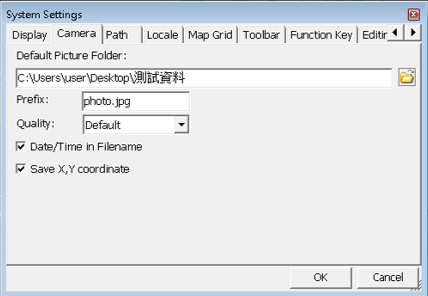
Camera Tab
Default Picture Folder: when the picture is taken, it is stored in this folder. Tap ![]() to select the storage folder.
to select the storage folder.
Prefix: every file you save will be given a name according to this prefix.
Quality: the quality of picture, four options including default, low, normal and high.
Date and Time in Filename: if the item is checked, when pictures are stored, date and time will be appended to prefix directly. Please see the part of file name of the figure on the upper right side.
Save X, Y Coordinate: if you take pictures with PDA equipped with GPS function, the coordinates of the place you take pictures will be saved. So, in the future, when you are arranging these pictures, they can be positioned directly on the map according to the coordinate values (the coordinate values are saved in EXIF Marker of JPG file).
NOTE: if PDA does not equip with camera function, the camera function in SuperPad can not be used. And it is only usable in smart device equipped with camera function, not for the PC. The obtained coordinate values will be stored in EXIF (Exchangeable Image File Format) of JPG file. EXIF refers to exchangeable image file format, which is used to set up the digital picture's information. It is a standard format to record the properties messages and data of the digital pictures. And the coordinate values are recorded in it.
© 2017 Supergeo Technologies Inc. All Rights Reserved.