
Adjusting Layer Display Order
![]()
![]() : Map is the display of overlapping many different types of layers. However, sometimes layers might mask the display of other layer(s). For example, the polygon layer might mask the display of point layer. GIS map is the result of overlapping many layers. Therefore, if the bottom layer is a point layer or a line layer whose features possess smaller area, the upper polygon layer, whose features possess larger area, might cause the bottom layer partial invisible. Thus, the point and line layers will not display clearly on the map. By viewing the icons on the left side of the layer name, you can learn the layer type,
: Map is the display of overlapping many different types of layers. However, sometimes layers might mask the display of other layer(s). For example, the polygon layer might mask the display of point layer. GIS map is the result of overlapping many layers. Therefore, if the bottom layer is a point layer or a line layer whose features possess smaller area, the upper polygon layer, whose features possess larger area, might cause the bottom layer partial invisible. Thus, the point and line layers will not display clearly on the map. By viewing the icons on the left side of the layer name, you can learn the layer type, ![]() refers to point layer,
refers to point layer, ![]() refers to line layer,
refers to line layer, ![]() refers to polygon layer, and
refers to polygon layer, and ![]() refers to image layer. The icons offer helpful information for adjusting the overlapping order. We suggest you to adjust the layer order right after the layers are added. If you want to add image layer, we suggest you to place it in the bottom place to avoid its large image covering other layer's display. Therefore the recommended order will be
refers to image layer. The icons offer helpful information for adjusting the overlapping order. We suggest you to adjust the layer order right after the layers are added. If you want to add image layer, we suggest you to place it in the bottom place to avoid its large image covering other layer's display. Therefore the recommended order will be ![]() point layer >
point layer > ![]() line layer >
line layer > ![]() polygon layer >
polygon layer > ![]() image layer from top to the bottom.
image layer from top to the bottom.
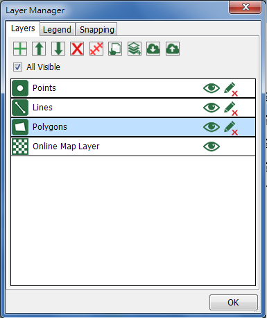
As you are adjusting the layer order, you need to select a layer first. When the layer is selected, tap![]() and the selected layer will be moved upward by one place; tap
and the selected layer will be moved upward by one place; tap ![]() and the selected layer will be moved downward by one place.
and the selected layer will be moved downward by one place.
After you have settled the order, tap OK and back to the map. You will find that the order changes based on the settings.
© 2017 Supergeo Technologies Inc. All Rights Reserved.