
Tutorial: Buffer Query
This chapter demonstrates the steps of creating a geo-processing on SuperGIS Desktop and publishing the geo-processing to SuperGIS Server to build an Ultra website. Through the example of demonstrating “Buffer Query” function below, you can comprehend how to manipulate the customized Geo-process with interface of the Ultra website.
Brief
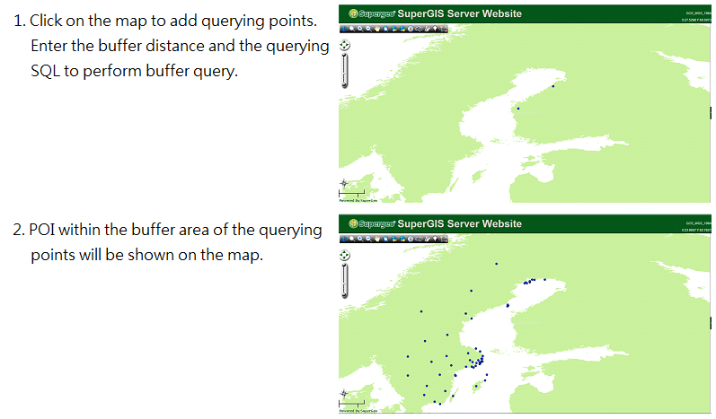
With “Buffer Query” function, users are able to add new querying points by clicking on the map, set buffer radius and query user POI by utilizing SQL. For example, if a Swedish local government wants to know which areas are influenced by emission from certain factories through the map, the personnel of the government can click on these factory positions on the map first, input buffer distance influenced by emission (i.e.100km) and then utilize SQL, “[Country] = ‘Sweden’”, to query the influenced area in Sweden. Please refer to the following pictures:
Preparation
Before building Buffer Query function, you need to design a analysis workflow through Process designer on the SuperGIS Desktop, as shown in the figure below:
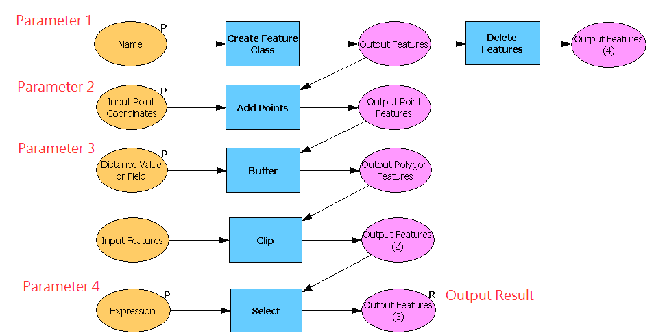
First of all, create a point layer through “Create Feature Class” to record querying points added by users and set “Name” that stands for file name as parameter 1 of the process. Subsequently, utilize “Add Points” function that is used to add new querying point, and set “Input Point Coordinates” as parameter 2. Users can add new query points by entering X and Y coordinates or clicking on the map. Then, use “Buffer” function to perform buffer and set “Distance Value or Field” that stands for buffer radius as parameter 3. And adopt “Clip” and “Select” functions to find out the features corresponding to querying conditions, set the querying condition, “Expression”, as parameter 4 to record SQL of querying condition, and export these features as result.
Publish and Use the Service
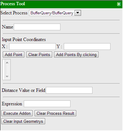
After publishing the project to the SuperGIS Server and activating Geo-processing service, you can use the service through building an Ultra website. Link to the Ultra website and click on Process Tool icon. Then, you can open the manipulation window as shown in the picture below. Parameter fields from top to bottom displayed in the following picture correspond to parameters that you designed in SuperGIS Desktop from one to four in order. Please enter parameters you require in each filed and then click “Execute Addon” to perform the analysis. Formats for each parameter are listed below.
To know how to build an Ultra website, please refer to “Building SuperGIS Server Ultra Website”(link. And refer to “Use the Published Geo-process through an Ultra Website” (link to know how to manipulate Process Tool.
Name: The field is used to record the layer name that users add querying points on. The field format is string. For example, if you enter “point”, a point layer whose name is “point” will be added.
X,Y: The field used to record information of the point coordinate that users add on the map. Users can choose to enter coordinate values or adopt “Add Points By clicking” and click on the map to add new querying points.
Distance Value or Field: The field is used to set buffer radius. The field format is numeric. For example, if you enter “10”, the buffer radius will be set as 10 units long.
Expression: The field is used to set querying condition. The field format is SQL syntax. For example, if you enter “[Country] = ‘Sweden’”, the features whose value in “Country” field is “Sweden.”
© 2013 SuperGeo Technologies Inc. All Rights Reserved.