SuperGIS Server Online Editing
SuperGIS Server online editing allows real-time editing the map data on server side through Internet service. Users could online edit the feature services published by SuperGIS Server in front-end applications that support; in brief, it allows editing features published by SuperGIS Server in general geographic information system, such as adding, deleting and modifying features.
Through the mechanism of map online editing, the storage space can be saved efficiently and data can be synchronized and shared. If multiple users are editing the same data at once, you neither have to copy data to every machine, nor worry synchronization fails since SuperGIS Server will help you control and maintain the data in latest status.
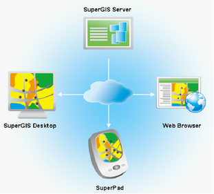
Three kinds of feature online editing solution are provided in SuperGIS Server at present. The first solution is SuperGIS Desktop; it allows front-end users to online edit features as well as synchronize feature data on server side with general desktop computers. The second is to use mobile GIS, SuperPad, with mobile device; it allows field surveyors to do survey without the need to taking lots of paper maps with them. Besides, with the mechanism of multi-user online editing in SuperGIS Server, the working efficiency then can be enhanced. The third, the feature service is able to be published in the form of webpage in SuperGIS Server, so the front-end users can real-time online edit through the general web browsers.
To create online editing environment in SuperGIS Server, you need to make the map data into map project file and publish it as SuperGIS Server Feature Service, so you can connect to server through front-end application and edit feature data. Map Service is the basic for SuperGIS Server Feature Service that you need to publish map project file as Map Service, and then set it the Feature Service which is allowed online editing. Familiar to Map Service, Feature Service contains multiple types of feature layers, and data providers could publish these layers of same property as the same Feature Service according to front-end request.
As a result, you do not have to concern whether the Feature Service published by SuperGIS Server displays correctly, since the Feature Service remains the map settings of the source map project, including feature style, text label, etc. So when front-end users connect to server and get the Feature Service, it is just like opening and browsing a map project in the local host machine.
©2017 Supergeo Technologies Inc. |