Cloud Computing and SuperGIS Server
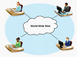
Cloud Computing is a popular issue in information technology industry in recent years. However what it refers to is not a new technology but an emerging "concept"due to the popularity of Internet service. The Cloud Computing is derived from the earlier "Distributed Computing"and "Grid Computing" whose main concepts are based on the Internet service, enabling computers to be tightly connected and cooperated. "Cloud"actually indicates "Internet" in brief Cloud Computing is to effectively apply the Internet sources and to build the communication channels among the computers, enabling these computers to work for the users or to offer Web services.
No matter Distributed Computing, Grid Computing or Cloud Computing, they all intend to disperse the large volume of complex operation into smaller operation units and then make them be processed in the huge computing system consisting of computers that connect to server. As a result, it takes only few minutes or seconds to accomplish the task that used to take much more time in one computer and the data is obtained easily and quickly as if the data fall from the cloud. In addition, the services provided by Cloud Computing usually allow users to use browsers only to access the various applications. As to software and data, they are stored and managed by Data Center.
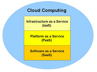
Since the concept of Cloud Computing came out, each science technology and software supplier has enthusiastically devoted to the research and development work on it. Therefore, many "new technologies"are produced by various different methods. Basically Cloud Computing can be divided into three tiers: Infrastructure as a Service (IaaS), Platform as a Service (PaaS) and Software as a Service (SaaS).
Currently in GIS field, the solutions, which are integrated with Cloud Computing, mainly work in the form of cooperation with various kinds of software and provide users with the various GIS services through the cooperation of server and front end software. SuperGIS Server is the server class software developed and based on this concept and all the SuperGIS Online services published by SuperGIS Server can be considered as "Software as a Service"tier.
SuperGIS Server can be divided into two parts, Client Object and Server Object. As long as the front end user installs the client object, he/she can obtain the on-line geographic information service published by SuperGIS Server or the permitted online-geographic information service through the medium of related front end software (like SuperGIS Desktop). After the Provider object is installed to the server side, the online-geographic information services can be managed or published. Such geographic information service published by SuperGIS Server used to take a lot of time and resources on analyzing or computing in a single machine but now they can return the request to SuperGIS Server and its back end computer resources to process collaboratively at once. After that, the results are transferred back to the user end and are displayed; in this way the front end users can reduce the waiting time and resources very effectively. In addition, users no longer need to install all functions to their own computers but will be able to obtain the various geographic information process functions through the Web Services published by SuperGIS Server in the future.
SuperGIS Server is a tool used to build the on-demand Web Service. When the services are built up, the general front end users can use the Web services or on-line functions by leasing or purchasing specific service. What the users need to focus on is the resources or services they need and where they can obtain the services instead of understanding the details and how the server operates.
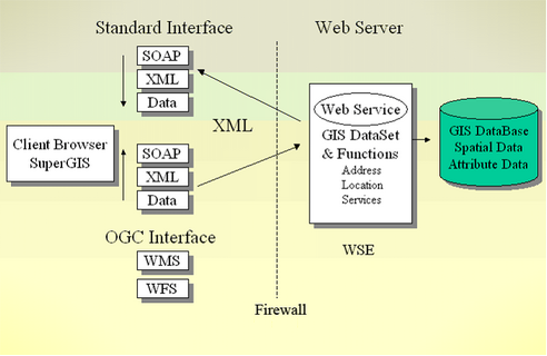
SuperGIS Server applies Web Service architecture as the foundation and adopts Web Service standard protocols, including HTTP, XML and SOAP. The geographic information service is saved in XML format and packed according to SOAP protocol. Then, the service is transmitted to Provider side through HTTP Port. When the service is processed by Provider side, the result will be returned in SOAP package, and XML documents will be provided. Thus, users can obtain the required geographic information service. Through these Web standard protocols, the Web Services built by SuperGIS Server can share and operate the common Web Service logic with the front end application for communication or sharing. Or even some of the functions not available in local host can be used on-line. At last, users can process the complex and time-consuming data and computing with Cloud Computing through the connection to many Containers via Provider.
If brief, SuperGIS Server is a set of server class geographic information software, which enables various Web Services to be published. Furthermore, SuperGIS Server is also a kind of tool to publish Cloud Computing services. So we can say using SuperGIS Server can create a perfect personal or enterprises geographic information service environment.
©2017 Supergeo Technologies Inc. |