SuperGIS Server Workflow
SuperGIS Server publishes all kinds of GIS data and functions for users to use and manipulate through the Internet. Front-end users do not need to understand the complicated structure or operation on server end; they have to know how to access the services published by SuperGIS Server only. The way to manipulate SuperGIS Server is as easy as to use general GIS software on local host. The difference is that the services published by SuperGIS Server can be accessed by multiple users simultaneously, which can facilitate users to share and publish GIS data efficiently.
Generally speaking, the workflow on SuperGIS Server can be categorized into the three steps below:
1. Combining GIS data to create project file. 2. Publishing project file as SuperGIS Server service. 3. Accessing service through front-end application.
Combining GIS data to create project file: The source GIS data are the basic GIS elements, including vector data, raster data, and even geodatabase data. We can integrate these basic GIS resource into the complete map data through geographic information system and then apply the data in other advanced GIS applications. SuperGIS Server supports three types of project file, SuperGIS Desktop Documents(*.sgd) created by SuperGIS Desktop is completely supported and SuperGIS Layer Document(*.slr) created by SuperGIS Desktop and SuperWebGIS Document(*.swg) created by SuperWebGIS are partially supported. SuperGIS Server can publish these three types of project file as various Internet services, such as Map Service, Feature Service, WMS, WFS, WCS, WMTS and KML Service, etc.
Basically, all of the formats supported by SuperGIS Desktop and SuperWebGIS can be created into project files and published as SuperGIS Server services. For instance, the geodatabase extension (GDB Client Extension) provided by SuperGIS Desktop can access the data stored in geodatabase. Users only need to connect to the geodatabase through this extension on SuperGIS Desktop to obtain the needed data and then save the needed data as project file (*.sgd) supported by SuperGIS Server. At last the project files can be published as multiple Internet services with SuperGIS Server.
Publishing project file as SuperGIS Server service After creating the project files, you can publish these project files as SuperGIS Server services through SuperGIS Server Manager to further manage and set the services items. For example, you can use the folder tree to categorize the published services in SuperGIS Server Manager. SuperGIS Server supports four basic services, such as Map Service, Feature Service, with which users are allowed to publish the advanced GIS Internet services. For instance, you can publish SuperGIS Server Map Service as OGC or KML Service through SuperGIS Server Manager.
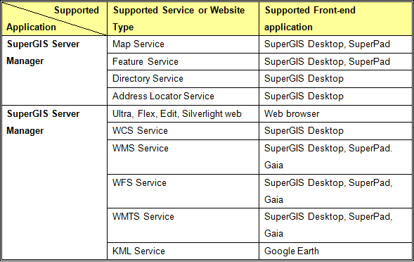
Accessing service through front-end application Generally, the services published by SuperGIS Server can be accessed only with the specific front-end application. The Map Service, Feature Service, Directory Service, and Address Locator Service mentioned above can be accessed and connected to server through SuperGIS Desktop or SuperPad. Moreover, SuperGIS Server Manager can embed SuperGIS Server Map Service and Feature Service into the webpage to display. Front-end users can directly apply web browsers to access these services and navigate the map as well. Certainly, if you publish the service as KML Service, you can use Google Earth to read the service and also manipulate the functions provided by Google Earth.
©2017 Supergeo Technologies Inc. |