
Open/Import/Create Parcel Data
To use the land parcel editor tool, you have to add the parcel data to the SuperGIS Desktop first by opening existing parcel data, importing existing personal geodatabase (.mdb file) and map layers, or creating a new parcel data. Once you add the parcel data, a parcel fabric will be added as a group of layer to SuperGIS Desktop, including the sublayers such as Control Points, Line Points, Points, Lines, and Parcels. The parcel fabric group layer is similar to a regular group layer in SuperGIS Desktop, yet layers cannot be added to, or remove from, the parcel fabric group layer.
Open Parcel Data
To use the land parcel editor tool, you have to add the parcel data to the SuperGIS Desktop first by opening existing parcel data, importing existing personal geodatabase (.mdb file) and map layer, or creating a new parcel data. To open existing parcel data, click Add Layer ![]() button and select the parcel data (the mdb file). Then click OK to add it to the SuperGIS Desktop. To import existing personal database and map layers, select Land Parcel>Import Parcel Data and select the database and map layers. Then click OK. To create your own parcel data, select Land Parcel>Create Parcel Data, and select the database. Then click OK to add the new parcel data.
button and select the parcel data (the mdb file). Then click OK to add it to the SuperGIS Desktop. To import existing personal database and map layers, select Land Parcel>Import Parcel Data and select the database and map layers. Then click OK. To create your own parcel data, select Land Parcel>Create Parcel Data, and select the database. Then click OK to add the new parcel data.
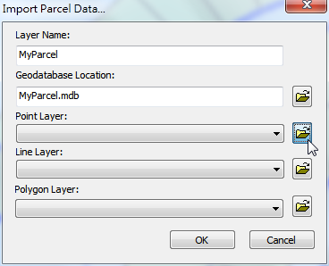
Import Parcel Data
You can import your map layers to turn them into parcel data format, including point, line, and polygon layers. To do so, you can click Land Parcel Editor>Import Parcel Data. And input the layer name and select the geodatabase and map layers you want to import. Then click OK to add them to the SuperGIS Desktop.
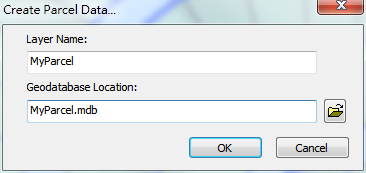
Create Parcel Data
You can create new parcel data by clicking Land Parcel Editor>Create Parcel Data. And input the layer name and select the geodatabase you want to use. Then click OK to create an empty parcel data.
©2015 Supergeo Technologies Inc. All rights reserved.