
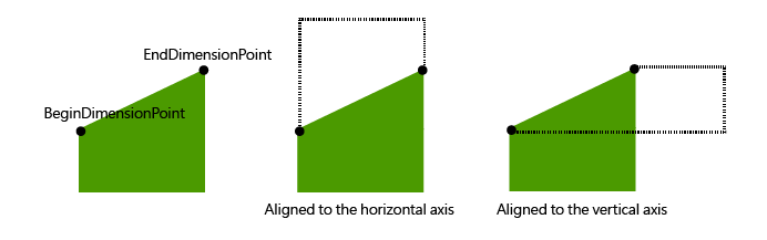
Linear Dimension
Linear dimension can be used to annotate the linear distance between two defined points as well. But, differing from aligned dimension/simple aligned dimension, linear dimension can do more than just represent linear distance. The linear dimension feature can be drawn as a vertical dimension or horizontal dimension. A vertical dimension line is used to annotate the vertical distance between the Begin dimension line point and the End dimension line point; and a horizontal dimension line annotates the horizontal distance between the two defined points.
What mentioned above is illustrated as the following figures:
1. By Target Layer select the target layer on which a new linear dimension line is planned to be drawn, click Add and choose Linear in the drop-down menu.
2. Click on the specified position on map to set the begin dimension point.
3. Move mouse pointer vertically/horizontally to draw a vertical/horizontal linear dimension line.
4. Double-click on the other specified position on map to set the end dimension line point. Then, a new linear dimension line is accomplished.
©2015 Supergeo Technologies Inc. All rights reserved.