
GPS Settings
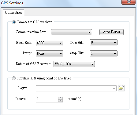
Open "GPS" toolbar, click "GPS Settings" on "GPS" drop-down menu. "GPS Settings" dialog box shows up.
.png)
Select "Connect to GPS receiver" or "Simulate GPS using point or line layer." You can only select one item from the two. While one item has been selected, the other item turns non-performable status. If you select "Connect to GPS receiver" please select the communication port to connect to GPS in "Communication Port." When you first open the tool, the item only lists the built-in communication ports. Besides you can select "Auto Detect", system will automatically link to various built-in effective communication ports. "Baud Rate" is the signal number per second GPS transfers, the default is 4800, or you can modify on your need. "Parity" enables you to select synch-checking type, five types are provided, including "None", "Odd", "Even", "Mark", and "Space." Besides, "Data Bits" is set 8 bits by default. "Stop Bits" is set 1 bit by default. "Datum of GPS Receiver" refers to the map datum applied by GPS receiver, it is WGS 1984.If you select "Simulate GPS using point or line layer", select a layer in "Layer" to simulate the GPS tracklog, the layer could be point or line layer. Set up the interval of GPS tracklog movement in "Interval", the unit is second.
NOTE: Before setting up "GPS settings", please close "GPS" first.
©2015 Supergeo Technologies Inc. All rights reserved.