
Measurement
While working with paper-based maps, we used pens and rulers to measure the area or length and even use the planimeter to measure the map. However, working with digital maps now, we can apply the measurement tools provided by SuperGIS Desktop to measure the length, area, etc on the map. There are 3 kinds of measurement tools, including Line Measurement ![]() , Area Measurement
, Area Measurement ![]() , and Feature Measurement
, and Feature Measurement ![]() . The first two tools can be used with mouse to drag the distance or area to measure. The third tool, Feature Measurement can measure the feature's perimeter, area, etc. When using the measurement tool, the measurement window will appear and display the measurement results in the window.
. The first two tools can be used with mouse to drag the distance or area to measure. The third tool, Feature Measurement can measure the feature's perimeter, area, etc. When using the measurement tool, the measurement window will appear and display the measurement results in the window.
•Line Measurement
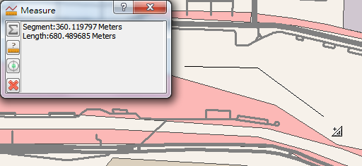
The window below is the result measured by "Line Measurement" tool. After clicking "Line Measurement" tool, click the location where you want to start to measure. Then, you can click to add a vertex to along a curve line. Double-click the location where you want to end measuring. In the process of measurement, the measure window will display the measurement results simultaneously. Segment means the length between the last vertex and the mouse current position. Length refers to the total length between the start point and the mouse current position.
If you need to measure several segments and calculate the sum of the lengths, you can click "Show Sum" button ![]() on "Measure" window. Then, apply the methods mentioned above to measure the first segment and then the second segment. Meanwhile, the "Sum Length" shows the sum of the length of the first and second segments, and so on.
on "Measure" window. Then, apply the methods mentioned above to measure the first segment and then the second segment. Meanwhile, the "Sum Length" shows the sum of the length of the first and second segments, and so on.
_new.png)
In "Measure" window, "Change Units" function ![]() provides numerous metric, British units, and decimal degrees for distance units and area units (decimal degrees can be applied to measure distance only). Users are allowed to choose the unit they need to measure. Since the measure result is recorded as the map unit, "Change Units" function only changes the display of measure result rather than the unit of the map itself. Furthermore, if "Snap to Features" function
provides numerous metric, British units, and decimal degrees for distance units and area units (decimal degrees can be applied to measure distance only). Users are allowed to choose the unit they need to measure. Since the measure result is recorded as the map unit, "Change Units" function only changes the display of measure result rather than the unit of the map itself. Furthermore, if "Snap to Features" function ![]() is clicked, the snapping function is activated according to the "Snap Settings" in "Start Editing" drop-down list. During measuring, as long as the mouse cursor is within the tolerance area, the mouse cursor will be snapped to the feature automatically to improve the accuracy of measurement. The "Clear Results"
is clicked, the snapping function is activated according to the "Snap Settings" in "Start Editing" drop-down list. During measuring, as long as the mouse cursor is within the tolerance area, the mouse cursor will be snapped to the feature automatically to improve the accuracy of measurement. The "Clear Results" ![]() is able to clear all the measure results in the current window.
is able to clear all the measure results in the current window.
_new.png)
_new.png)
•Area Measurement
Using "Measuring Area" tool ![]() , users can drag a polygon to measure the area. The way to measure is to click "Area Measurement" and click the position where you want to start to measure the polygon and click again to add another vertex of the polygon, and repeat the actions to finish the polygon. You can double-click to finish the area settings. During the process of measuring, the measure results will be displayed in "Measure" window, including the segment (the distance between the last vertex and the mouse cursor), perimeter, and area. Moreover, the other functions in the window, like "Sum", are the same as the methods of "Line Measurement." Please refer to the description of "Line Measurement."
, users can drag a polygon to measure the area. The way to measure is to click "Area Measurement" and click the position where you want to start to measure the polygon and click again to add another vertex of the polygon, and repeat the actions to finish the polygon. You can double-click to finish the area settings. During the process of measuring, the measure results will be displayed in "Measure" window, including the segment (the distance between the last vertex and the mouse cursor), perimeter, and area. Moreover, the other functions in the window, like "Sum", are the same as the methods of "Line Measurement." Please refer to the description of "Line Measurement."
_new.png)
_new.png)
•Feature Measurement
After clicking "Feature Measurement" tool ![]() , you can measure the point, line, polygon features respectively. For point features, the coordinates of the point features will be displayed in the "Measure" window as the point feature is clicked by "Feature Measurement" tool. However, the "Sum" function is useless foe point features.
, you can measure the point, line, polygon features respectively. For point features, the coordinates of the point features will be displayed in the "Measure" window as the point feature is clicked by "Feature Measurement" tool. However, the "Sum" function is useless foe point features.
_new.png)
As a line feature is clicked by "Feature Measurement", the length of the line feature will be displayed in the "Measure" window. If you click "Sum", the sum length will be displayed in the window as you click another line feature.
_new.png)
.png)
If you measure a polygon feature, the perimeter and area of the feature will be displayed in the "Measure" window. Similarly, if you click "Sum" and click other polygon features, the window will show the "Sum Perimeter" and "Sum Area."
_new.png)

NOTE:When you use "Feature Measurement" tool ![]() , the "Sum" function
, the "Sum" function ![]() can be only applied to the same type of features so that the system can calculate the measure results.
can be only applied to the same type of features so that the system can calculate the measure results.
©2015 Supergeo Technologies Inc. All rights reserved.