
Relating Tables
Relating tables is to relate the fields of the same properties from two layers and make a relation on properties of the corresponding fields. After the Tables are related, whenever inquiring features in one of the two layers, the system will tell you not only the data of the feature recorded in the belonging layer but also the data of the feature recorded in the other one. The information will be revealed in the "Identify" dialog box.
To relate tables, right-click on the target layer and click properties, and then switch to Relate and Join tab. Click Add to open Relate window. Select the field used to perform relate in the Source Fields section. Then select the target table from the Table lists and the field to use from the Fields list in the Relate Target section. If the table you need does not exist in the table list, you can click the open file icon the choose the table you need. After all the tables and fields are provided, click OK to proceed.
.png)
.png)
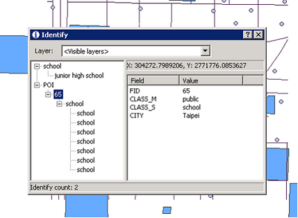
Go back to the map window, select the "Identify" button on the map toolbar and select a feature on the POI layer, which you just set as the "Source Field." You will see in the left panel the level under POI is the feature you just selected; in this example, the selected feature is School. And you will find one more level, the layer you just selected as the "Relate Target", Park layer, under this feature. The level under Park layer contains all its features of attribute properties as school.
©2015 Supergeo Technologies Inc. All rights reserved.