
Going to X, Y
Click "Goto" tool ![]() at the lower right corner of the window or click “File” on main menu and choose “Go To XY”, the "Goto" dialog box shows up. In the dialog box enter coordinates within the map extent and click "Pan To"
at the lower right corner of the window or click “File” on main menu and choose “Go To XY”, the "Goto" dialog box shows up. In the dialog box enter coordinates within the map extent and click "Pan To" ![]() , the position of the coordinates will center to the map window. In addition, if you select "Flash"
, the position of the coordinates will center to the map window. In addition, if you select "Flash"![]() the position of entered coordinates will flash. Meanwhile, clicking "Add Marker"
the position of entered coordinates will flash. Meanwhile, clicking "Add Marker"![]() will add a marker on the position of the entered coordinates.
will add a marker on the position of the entered coordinates.
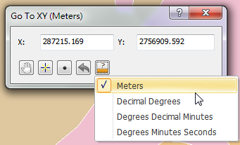
To set XY coordinates, you can choose longitude and latitude or the map unit you set. Click "Change Unit" button![]() , you can choose the unit. If you choose "Degree Minute Seconds", you can directly input the longitude and latitude. Meanwhile, you can leave a space between degree and minute or between minute and second. If you choose map unit, like "Meters", you can input the coordinates directly. If the coordinate system of your map is projected coordinate system, you still can use longitude and latitude to move. However, please note that the coordinate system of Layers should be the same as the one of the layer.
, you can choose the unit. If you choose "Degree Minute Seconds", you can directly input the longitude and latitude. Meanwhile, you can leave a space between degree and minute or between minute and second. If you choose map unit, like "Meters", you can input the coordinates directly. If the coordinate system of your map is projected coordinate system, you still can use longitude and latitude to move. However, please note that the coordinate system of Layers should be the same as the one of the layer.

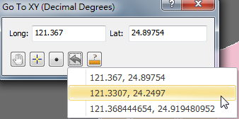
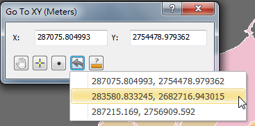
Moreover, click "Recent Query" ![]() , and the recent query results will be listed. You can click the record to query again or mark the position. The query record will be listed in the format as the same as the unit you choose. The lower left graph is degree, minute, second; the lower right graph is map unit, meters.
, and the recent query results will be listed. You can click the record to query again or mark the position. The query record will be listed in the format as the same as the unit you choose. The lower left graph is degree, minute, second; the lower right graph is map unit, meters.
©2015 Supergeo Technologies Inc. All rights reserved.