
Creating XY data
"Creating XY data" is to create a DBF file or an Excel file with the coordinates of the point features you would like to add. Then, you can directly import the file to SuperGIS Desktop to add point features. Here, take excel for example. Firstly, you can click "Full Extent" tool ![]() on the "Tools" toolbar to display the whole map and to make sure the complete coordinate range of the map. While the mouse cursor is moving around the map, the lower-right corner of the window will show the coordinates of the mouse cursor current position.
on the "Tools" toolbar to display the whole map and to make sure the complete coordinate range of the map. While the mouse cursor is moving around the map, the lower-right corner of the window will show the coordinates of the mouse cursor current position.
.png)
![]()
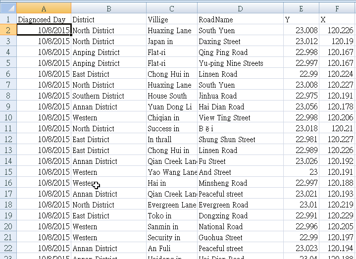
After making sure the coordinates of the point features you want to add, you can open Excel file and type X coordinate in column A and type Y coordinate in column B. Then, type 3 sets of coordinates, which are (229579 , 2441350), (220463 , 2435581), and (225586 , 2432354).
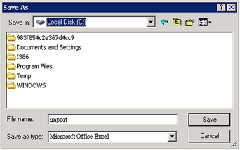
After typing the coordinates, please click "Save" ![]() and specify the path to save in the file. Then, name the file (the sample is “import”). Click "Save" to complete saving.
and specify the path to save in the file. Then, name the file (the sample is “import”). Click "Save" to complete saving.
©2015 Supergeo Technologies Inc. All rights reserved.