
Closest Facilities
Like what its name presents, Closest Facilities helps us find the facilities closest to the incident with a given range defined by distance or traveling time, and shows the optimal route from the incident to the closest facilities. For instance, the closest hospital to the car accident, the closest convenience store to one¡¦s apartment, etc.
In the Closest Facilities solver, we need to use two types of stop, one represents the event points (Incident), and the other stands the facilities to search (Facility). In addition, you can also assign the barriers (Barrier) if needed. Let's take the following figure for example:
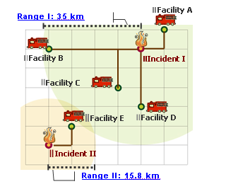
There are two incidents, Incident I and Incident II; five facilities, Facility A to E. The range of Incident II is 15.8 km and Incident I has a 35 km range. Thus, as we apply this Closest Facilities method, Network Analyst will provide us with the path from the Incident to the facilities under the range constrain. In this example, four facilities (A, B, C, and D) are within in the wide range of Incident I but only Facility E is within the range of Event II.
In addition to getting the positions of the closest facilities and optimal routes by setting distance, users can get the result by setting time (the traveling time to facility), count(the count of facility to search), direction(from incident to facility or from facility to incident), CurbApproach(the facility is located in the left side, right side or any place to the vehicle) in SuperGIS.
©2016 Supergeo Technologies Inc. All rights reserved.