
Settings Options
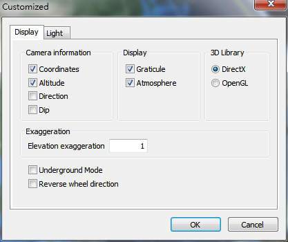
Users can choose to show camera information, and set the elevation exaggeration.
1.Camera information: Users can choose to show camera coordinates, altitude, direction, dip.
2.Display: Select whether to show graticule and atmosphere or not.
3.3D Library: Set to use DirectX or OpenGL
4.Exaggeration: Set the elevation exaggeration. The displayed elevation will the the original elevation multiplied by this value, which is between 0.01 to 3.00.
5.Select to enable Underground mode and whether to reverse wheel direction. The underground mode allows users to observe underground utilities, and the underground depth is 50 meters. If you want to see underground objects when underground mode is on, hold Crtl and zoom in towards the ground to dive underground.
© 2016 Supergeo Technologies Inc. All Rights Reserved.