
Interface of SuperGIS Globe
•SuperGIS Globe Main Menu
File: File menu includes Print, Export images, and Exit.
Print: Prints the current view of SuperGIS Globe.
Export images: Exports the current view of SuperGIS Globe.
Exit: Close SuperGIS Globe。
View: View menu includes Zoom and Settings.
Zoom: Zoom in/ out, or zoom to full extent.
Settings: Set the display of graticule, camera coordinates, directions, dip.
About: About menu includes the manual of SuperGIS Globe and information of SuperGIS Globe.
SuperGIS Globe Manual: Open SuperGIS Globe manual.
About SuperGIS Globe: Show information about SupeGIS Globe.
•SuperGIS Globe 3D Navigator
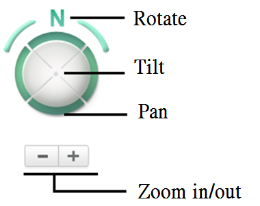
You can navigate in the SuperGIS Globe by using mouse and keyboard, including:
1.Zoom in: Rotate backward of the middle mouse button.
2.Zoom out: Rotate forward of the middle mouse button.
3.Pan: Click and drag the left mouse button, the globe will rotate according the dragging direction.
4.Rotate and tilt: Drag the LMB and hold Ctrl to rotate and tilt the camera direction. Drag the LMB and hold Shift to rotate and tilt the camera position.
•SuperGIS Globe Standard Toolbar
![]() Open new file
Open new file ![]() Open existing files
Open existing files ![]() Save projects
Save projects ![]() Print
Print
![]() Add layers
Add layers ![]() Add terrain
Add terrain ![]() Manual
Manual
![]() Settings
Settings
•SuperGIS Globe Navigation Toolbar
![]() Zoom in
Zoom in ![]() Zoom out
Zoom out ![]() Target
Target ![]() Zoom to Target
Zoom to Target
![]() Zoom to full extent
Zoom to full extent ![]() Bookmark manager
Bookmark manager ![]() Fly tool
Fly tool
•SuperGIS Globe GIS Toolbar
![]() Select features
Select features ![]() Cancel selection
Cancel selection ![]() Set-up selection tool
Set-up selection tool ![]() Export images
Export images
![]() Find
Find ![]() Identify
Identify ![]() Measurement
Measurement ![]() Record 3D videos
Record 3D videos
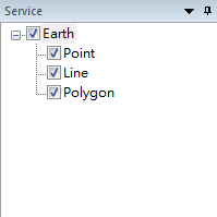
•Table of Content
Table of Content shows the layers added to SuperGIS Globe.
© 2016 Supergeo Technologies Inc. All Rights Reserved.