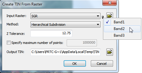
Create TIN from Raster
1.Click “Create TIN” and then choose “from Raster” in the drop-down menu of 3D Analyst toolbar. 2.Check an existing vector data on the list of “Input Raster”, or click 3.Select method you want to use such as “Very Important Point”, “Drop Heuristic” or “Hierarchical Subdivision” on the box named “Method.” 4.Enter tolerance value on the box named “z Tolerance”, which is the maximum difference in z unit between input raster layer and output TIN. 5.You can also specify maximum number of points in the output TIN. 6.Specify the path and file to save the output TIN data on the box named “Output Tin”, or click 7.Click “OK” to create TIN from raster.
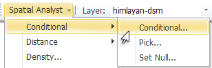
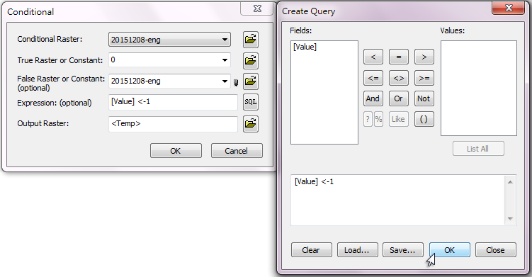
NOTE: The extreme value you put in the raster data could cause time consumption during calculation. Please make sure that you process the raster data in advance. To do so, you need to apply Spatial Analyst ahead of time to filter the extreme value in your raster data, e.g. conditional outliers, then use 3D Analyst to convert raster data to TIN. In the following example, the value, -32767, is assumed as the conditional outlier in raster data. To filter this conditional value, you need to activate Spatial Analyst, click Spatial Analyst> Conditional> Conditional…, set True Raster or Constant and use Expression to set the condition as [Value] < -1. In this way, you can filter all the value that are smaller than -1 and apply 3D Analyst subsequently to convert the raster data into TIN.
©2016 Supergeo Technologies Inc. All rights reserved. |